The last three minutes: Eagle's final approach, reconstructed — then measured against the 2011 ground truth
The mission’s defining episode — program P64 pitchover to
engine stop, 102:41:32 → 102:45:40 GET — braided from the three independent 1969
records the library holds: the
Mission Report’s telemetry-derived
event log (Table 5-I) and descent narrative (§5.3–5.4), the
GOSS NET 1 air-to-ground transcript
(the loop), and the
CM onboard (DSE) transcription
(Columbia’s recorder, taping the LM crew’s voices as received). Then the loop is
closed forty-two years forward: the geometry the 1969 documents describe —
West crater, the range extension, the landing point — is measured directly on
the library’s 2011 LROC NAC frame
(M175124932R, 25 cm/px), extending the pixel work of the
Tranquility Base photo-map. Every
quotation below was re-verified against the raw files (the transcript HTML, the
DSE text edition with its garbles checked against page renders of the original
typescript, the Mission Report’s text layer with the propellant table and
Table 5-I read from page renders). GETs are the sources’ own tags
(04 06 45 40 → 4×24+6 = 102:45:40).
Addendum (2026-06-12, later the same day): the discrepancy ledger (entry A1) found that the measured stand-off was in the 1969 record all along — PSR ch. 4 (soil mechanics, printed p. 102) places the LM “approximately 130 m north and 600 m west of West Crater,” matching this analysis’s measurement (113 m N, 564 m W) within ~40 m. The “about 400 meters” of the geology chapter and the Mission Report is therefore not just imprecise but one side of an internal 1969 conflict that the LROC measurement adjudicates.
The shape of the problem
Section titled “The shape of the problem”Three things were already wrong, or about to be, when Eagle pitched over for the final approach (powered descent and landing):
- The ship wasn’t where its computer thought it was. The onboard state vector was about 21 000 feet up-range of truth at powered descent initiation, detected as a growing Doppler residual on the ground and by Armstrong’s own mark — the landing-point-designator sighting on crater Maskelyne W came “approximately 3 seconds early, confirming the suspected downrange error” (Mission Report §5.2–5.3, pp. 5-3 – 5-4). Eagle was going to land long, into terrain nobody had certified.
- The computer kept crying out. Five program alarms (1202 at 102:38:22 and 102:39:02; 1201 at 102:42:18; 1202 at 102:42:43 and 102:42:58 — Table 5-I) “did not degrade the performance of any primary guidance or control function, but they did interfere with an early assessment by the crew of the landing approach” (§5.3). In the crew debriefing (§9) Armstrong is blunter: the concern was “whether we could continue at all,” and attention was forced inside the cockpit until below ~2000 feet.
- The aim point was bad. When Armstrong finally looked out, the landing-point designator “indicated that the approach path was leading into a large crater” — the sharp-rimmed, blocky, ~180 m ray crater afterward unofficially named West crater (§5.3; §11, p. 11-3).
What followed — redesignation, manual takeover at ~600 feet, a low-level fuel light, and touchdown 72 seconds later — is below, second by second, in all three records at once.
The braided timeline — P64 to engine stop
Section titled “The braided timeline — P64 to engine stop”Columns: the Mission Report’s telemetry event log (Table 5-I, p. 5-13); the air-to-ground loop (GOSS NET 1); and the cabin as Columbia’s recorder caught it (DSE — LM voices as received aboard the CSM, with Houston’s uplink essentially absent). Ellipses are the transcripts’ own garble marks.
| GET | Telemetry (Table 5-I) | The loop (GOSS NET 1) | The cabin (CM DSE) |
|---|---|---|---|
| 102:41:32 | Enter program P64 (pitchover, landing radar to position 2 at :37) | 102:41:35 LMP: “P64.” | |
| 102:41:53 | Attitude-hold — handling-qualities check | 102:42:05 CDR: “Manual attitude control is good.” | 102:42:01 CDR: “Attitude control is good — manual attitude control is good. Okay, 3070.” |
| 102:42:03 | Back to automatic guidance | ||
| 102:42:10 | CC: “Eagle, Houston. You’re GO for landing. Over.” | ||
| 102:42:17–18 | 1201 alarm | LMP: “Roger. Understand. GO for landing. 3000 feet. PROGRAM ALARM.” … LMP/CDR: “1201” / “1201.” | LMP: “Roger; understand. Go for landing, 3000 feet. Program alarm — 1201.” CDR: “1201. Okay. 2050.” |
| 102:42:25 | CC: “Roger. 1201 alarm. We’re GO. Same type. We’re GO.” | ||
| 102:42:30–37 | LMP: “2000 feet. 2000 feet. Into the AGS, 47 degrees.” | CDR: “Give me an LPD.” … CDR: “Give me an LPD.” LMP: “47 degrees.” CDR: “47.” | |
| 102:42:38 | CDR: “That’s not a bad-looking area. Okay.” | ||
| 102:42:43, :58 | 1202 alarms (computer-determined) | 102:42:58 CC: “Roger. 1202. We copy it.” | 102:42:55 CDR: “What’s LPD?“ |
| 102:43:01–07 | LMP: “35 degrees. 35 degrees. 750. Coming down to 23.” … “700 feet, 21 down, 33 degrees.” | LMP: “35 degrees, 35 degrees; 750, … coming down to 23.” | |
| 102:43:08 | CDR: “Pretty rocky area.” | ||
| 102:43:09 | Landing point redesignation | ||
| 102:43:13 | Attitude-hold — manual takeover (~600 ft) | 102:43:11 LMP: “600 feet, down at 19.” | LMP: “600 feet, down to 19; 540 feet, down to 30, down to 15.” |
| 102:43:22 | Enter P66 — rate-of-descent mode (~400 ft) | 102:43:26 LMP: “At 400 feet, down at 9.” … :29: ”… forward.” | LMP: “Okay, 400 feet, down to 9, 58 forward.” |
| 102:43:46–52 | LMP: “300 feet, down 3½, 47 forward.” … “On 1 a minute, 1½ down.” | LMP: “300 feet down, 3½, 47 forward. Coming up — 1 a minute, 1½ down. Moving out.” | |
| 102:43:57 | 102:43:57 CDR: “70.” | CDR: “Okay, how’s the fuel?” LMP: “Wait just a minute.” | |
| 102:44:00 | 102:44:04 LMP: “Watch your shadow out there.” | **CDR: “Okay, Ed, this looks like a good area here.”**¹ LMP: “I got the shadow out there.” | |
| 102:44:07–26 | (102:44:11 landing radar data drop, good again :21) | LMP: “50, down at 2½, 19 forward.” … “220 feet, 13 forward.” … “200 feet, 4½ down.” | LMP: “Altitude velocity light, 3½ down, 220 feet; 13 forward, 11 forward, coming down nicely. 200 feet.” |
| 102:44:28 | Red-line low-level sensor light — 72 s of propellant questions begin | ||
| 102:44:40–54 | LMP: “120 feet.” … “100 feet, 3½ down, 9 forward. Five percent.” … “Okay. 75 feet. There’s looking good.” | LMP: “100 feet, 3½ down, 9 forward. 5 percent —.” … “Okay, 75 feet. And it’s looking good; down a half … light’s on.” | |
| 102:45:02 | CC: “60 seconds.” | ||
| 102:45:17–21 | LMP: “40 feet, down 2½. Kicking up some dust.” … “30 feet, 2½ down. Faint shadow.” | LMP: “Looks good, 40 feet down, 2½. Picking up some dust. 30 feet, 2½ down — straight down.” | |
| 102:45:26 | LMP: “4 forward. 4 forward. Drifting to the right a little. Okay. Down a half.” | LMP: “20 feet, down a half; drifting forward just a little bit. Good. Okay.” | |
| 102:45:31 | CC: “30 seconds.” CDR: “Forward drift?” LMP: “Yes.” | ||
| 102:45:40 | LANDING / engine off (102:45:39.9) | LMP: “CONTACT LIGHT.” | 102:45:41 CDR: “SHUTDOWN.” |
| 102:45:43–47 | LMP: “Okay. ENGINE STOP.” … “ACA — out of DETENT.” CDR: “Out of DETENT.” | LMP: “Okay. ENGINE STOP; ACA out of DETENT.” CDR: “Out of DETENT.” | |
| 102:45:57 | CC: “We copy you down, Eagle.” | ||
| 102:45:59 | CDR (now tagged TRANQ): “Houston, Tranquility Base here. THE EAGLE HAS LANDED.” | 102:45:58 CDR: “Houston — Tranquility Base here. THE EAGLE HAS LANDED.” |
¹ As printed in the 1969 typescript (verified on a page render of the original, p. 177): “Okay, Ed, this looks like a good area here.” No “Ed” was aboard — a transcriber’s artifact in the official record (the transcribers, working from the tape, most plausibly misrendered a muffled “Buzz” or a clipped word). The three-records comparison catalogs sibling divergences (“Kicking”/“Picking”); this one is new to the register.
What only the cabin record carries. The loop’s version of these minutes is Aldrin’s data stream with Houston’s two fuel calls. The DSE preserves the decision layer the loop never heard: Armstrong twice demanding a landing-point-designator angle (“Give me an LPD”) seconds after the 1201 alarm, his terrain verdicts in real time (“That’s not a bad-looking area” → “Pretty rocky area” → “this looks like a good area here”), and the only spoken fuel worry of the descent — “Okay, how’s the fuel?” — at 102:43:57, half a minute before the low-level light. It also carries a final altitude callout (“20 feet, down a half”) below the loop’s last (“30 feet”), and Armstrong’s own “SHUTDOWN” — the cabin-side twin of the loop’s “CONTACT LIGHT,” as already noted in the three-records study.
The fuel ledger
Section titled “The fuel ledger”The drama’s currency was descent propellant. The Mission Report settles the account exactly (§9.13.1, table p. 9-32, read from a page render):
| Quantity (fuel + oxidizer) | Pounds |
|---|---|
| Loaded | 18 184 |
| Consumed — preflight nominal plan | 17 010 |
| Preflight allowance for redesignation | 103 |
| Preflight allowance for manual hover | 114 |
| Actually consumed | 17 414 |
| Remaining at engine cutoff | 770 (vs. 957 planned) |
So the preflight budget had set aside 217 lb for exactly the maneuver Armstrong flew — and the flying consumed that plus the 187-lb margin difference. The report’s verdict: “propellant usage was greater than predicted because of the additional time required for the landing site redesignation… Allowance for manual hover and landing point redesignation was in the preflight budget but was not considered part of the nominal usage” (§9.13.1). The hand-flying was also rate-expensive: reaction-control usage in manual descent ran “approximately 1½ times greater than that for the automatic mode,” ~95 lb against 40 predicted (§5.3, p. 5-6).
The clock side of the ledger: the red-line low-level sensor light at 102:44:28 (Table 5-I) — the event behind Aldrin’s “light’s on” and the DSE’s “5 percent” — came 72 seconds before touchdown, bracketed by the only two things Houston said in the final two minutes: “60 seconds” and “30 seconds.” Armstrong, in 2001, kept the margin in proportion: with rates stabilized the LM could drop “perhaps maybe forty feet or more in the low lunar gravity… So I was perhaps probably less concerned about it than a lot of people watching down here on Earth.”
And the landing itself, from telemetry (§5.4, p. 5-6): touchdown at 102:45:39.9, “negligible forward velocity, approximately 2.1 ft/sec to the crew’s left and 1.7 ft/sec vertically”; maximum post-contact rock-up about 2 degrees; footpads in 2.5–3.5 inches; the gear struts stroked less than an inch — about 10 percent of one cartridge’s energy absorption. After four program alarms, a boulder field, and a fuel light, Eagle set down using a tenth of its landing gear.
The ground truth, 42 years later
Section titled “The ground truth, 42 years later”Everything above is the 1969 record describing a place. The library also holds the place itself: the 2011 LROC NAC frame resolves the descent stage, the crater Armstrong refused, and the ground between them at 25 cm/px. Measuring that geometry directly on the raw image — the same saturated-pixel method as the photo-map — closes the loop:
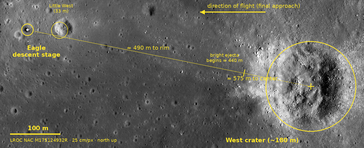
Measured on the frame (descent stage located at pixel (669, 897) by saturation centroid; West crater’s bowl fitted from its high-contrast boulder-and-shadow interior, center pixel ≈ (2927, 1349); uncertainties ≈ ±20 m on the crater figures):
| Quantity | 1969 record | Measured on the 2011 frame |
|---|---|---|
| West crater diameter | ”approximately 180 meters… 30 meters deep” (§11, p. 11-3) | rim-to-rim ≈ 160–190 m ✓ |
| Little West crater | 33 m diameter, “about 50 meters east of the lunar module” (§11, pp. 11-6 – 11-7) | center 64 m east ⇒ near rim ≈ 47 m ✓ (also the scale check: 256 px × 0.25 m = 64 m) |
| Blocky ejecta | apron “extends… about 250 meters from the rim crest”; the LM “landed between these rays” (§11, p. 11-3) | distinct albedo brightening from ≈ 440 m out from the LM along the baseline; boulder-resolved roughness from ≈ 500 m |
| West crater stand-off | ”About 400 meters east of the landing point” (§11, pp. 11-3, 11-7) | ≈ 490 m to the near rim crest; ≈ 575 m (1 890 ft) to the bowl center, bearing east-southeast |
Three of the four 1969 numbers survive contact with the orbital photograph unchanged. The fourth is the interesting one:
The report’s “about 400 meters” understates the stand-off. Whichever referent the geologists meant, the measured figure is larger — the rim crest is ~490 m from the descent stage, the crater center ~575 m. The 1969 number was a round estimate made from descent film and crew description before the site had ever been surveyed from orbit at this resolution; the same section locates the landing point “to within about 8 meters” relative to local features, which is exactly what lets a 2011 photograph re-measure the baseline. (The figure Armstrong actually flew — “approximately 1100 feet [335 m] downrange from the initial aim point,” §5.3 — is a different quantity, measured from the computer’s aim point rather than from the crater, and is not contradicted; the measurement here cannot resolve where that aim point sat within the ejecta field.) Worth noting: this is a new entry for the cross-source ledger, not a correction to the wiki’s own arithmetic — the LROC concept and powered-descent concept currently repeat the report’s ~400 m and should carry the measured value alongside it.
Read against the timeline above, the strip image is the last 90 seconds laid on the ground: the bright apron edge at ~440 m is roughly the terrain under Eagle around the “100 feet… 5 percent” call; the clean gray mare between the rays — “this looks like a good area here” — is where the dust started flying at 40 feet; and the trail to Little West at the left edge is Armstrong’s late-EVA jog back out to photograph the kind of crater he had spent the descent avoiding, 33 m instead of 180.
Method and verification
Section titled “Method and verification”- Voice records: GOSS NET 1 quotes read from the raw transcript HTML (Tape
66/5–66/13, pp. 310–318); DSE quotes from the raw
_djvu.txtedition with OCR-suspect lines (the “Ed” line, “20 feet, down a half,” “Picking up some dust,” “SHUTDOWN”) verified against 160–300 dpi renders of the original typescript pages (pp. 176–178 of the PDF). - Telemetry and tables: Table 5-I (p. 5-13), the propellant table (p. 9-32), and the touchdown-dynamics figures read from page renders where the text layer garbled digits; narrative quotes from the text layer of §5.2–5.4, §9.13, §11.
- Image measurement: raw LROC GeoTIFF (4000×2400 px, 25 cm/px, north up — untouched). Descent stage = centroid of the saturated-pixel cluster at (660–680, 890–910). West crater bowl = median center of pixels with extreme local contrast (7×7 σ > 35) over the eastern quadrant, cross-checked against the saturated shadow band of its eastern inner wall and a brightness/roughness profile along the LM–crater line (mare flat to ~430 m; albedo step ≈ 440 m; boulder roughness from ≈ 500–530 m; bowl ≈ 530–670 m on that line). Scale independently confirmed by Little West (measured 64 m vs. the report’s ~50 m-to-rim + 33 m diameter) and the photo-map’s EASEP baseline (~24 m vs. “~70 ft”). Annotated strip built with Pillow from a crop of the raw frame.
Sources
Section titled “Sources”- Apollo 11 Mission Report (MSC-00171) — Table 5-I event times; §5.2–5.4 descent narrative and landing dynamics; §9.13.1 propellant; §11 site geology and landing-point determination
- Apollo 11 Technical Air-to-Ground Voice Transcription — the loop, verbatim
- Apollo 11 Onboard Voice Transcription (CM DSE) — the cabin as received aboard Columbia, verbatim
- Apollo 11 Technical Crew Debriefing — Vol. 1 — §9, the crew’s eleven-days-later account
- Neil A. Armstrong — JSC Oral History (2001) — the 32-years-later recollection (memory-vs-record context)
- LROC NAC imagery of the Apollo 11 landing site — the measured frame; method per the photo-map
- Wiki concepts as linked throughout, especially powered descent and landing