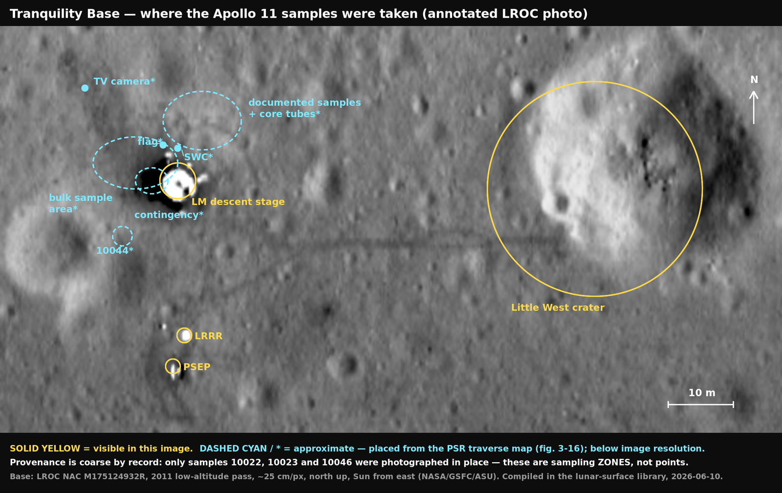
Tranquility Base photo-map — where the samples were taken
An annotated photo-map: the sampling areas, deployed hardware, and EVA landmarks of Tranquility Base superimposed on the library’s LROC NAC photograph of the landing site (M175124932R, 2011, ~25 cm/px, north up).
Caveat added 2026-06-12: the dashed documented-samples ellipse (north-northeast, transferred from PSR fig. 3-16) sits on one side of a genuine conflict in the primary record — the crew’s own PSR chapter says the documented rocks came from “15 to 20 ft north of the LM,” but the Mission Report and Sample Catalogue say “south… near the east rim of the large double crater.” Treat that ellipse as the PSR’s placement, not a settled fact — see the discrepancy ledger, entry C.
The honest limit first: zones, not pins
Section titled “The honest limit first: zones, not pins”A per-sample pin map of all 53 samples is not possible from the record, and this library already documents why: documented sampling — the part that ties a rock to a photographed spot — was cut to about ten minutes, so “most Apollo 11 samples lack precise field provenance” (lunar field geology). Only 10022, 10023, and 10046 were photographed in place; only the sampling areas are mapped in the mission record (the Preliminary Science Report’s traverse map, fig. 3-16). This photo-map therefore shows the three sampling zones plus the one coarsely-located rock the wiki records (10044), and marks them as approximate.
What the map shows
Section titled “What the map shows”| Marker | Feature | Basis | Record |
|---|---|---|---|
| Yellow circle (center) | LM descent stage (Eagle) | Visible — brightest object in frame, located by pixel saturation | Lunar Module Eagle, landed 102:45:40 GET |
| Yellow circles (south) | LRRR (nearer) and PSEP (farther), ~24 m south of the LM — the deployment’s “~70 ft” | Visible — two bright dots with scuffed apron | LRRR · PSE · EASEP deployment, 111:02–111:12 GET |
| Yellow ring (east) | Little West crater — ring drawn at the Mission Report’s 33-m diameter, ~60 m east; the dark trail of Armstrong’s late-EVA jog is visible running to it | Visible | field geology · EVA timeline, ~111:16+ GET |
| Dashed cyan ellipse at the LM’s west side | Contingency sample zone — “immediately in front of the LM” (the ladder/+Z side); sample 10010, parent of rocks 10021–10032 | Approximate (PSR fig. 3-16 + sample collection) | bagged 109:37:08 GET |
| Dashed cyan ellipse (west-northwest) | Bulk sample area — ~20 scoops near the MESA | Approximate (PSR fig. 3-16) | sealed 110:35:56 GET |
| Dashed cyan ellipse (north-northeast) | Documented samples + core tubes — the truncated final sampling, both drive tubes “within a few metres of the LM” | Approximate (PSR fig. 3-16) | 111:16–111:26 GET |
| Dashed cyan circle (southwest) | 10044 — picked up “between the LM and the elongate double crater to the southwest” | Approximate (field geology) | — |
| Cyan dots | Flag, SWC foil, TV camera | Approximate (PSR fig. 3-16; below image resolution) | ceremonial 110:09:43 · SWC 109:58:32 · TV ~109:30 GET |
Method
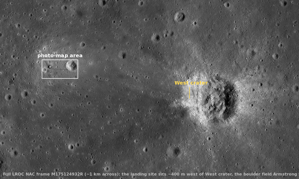
Section titled “Method”- Base image: the library’s raw LROC NAC frame (4000 × 2400 px, 25 cm/px, north up), cropped to 480 × 250 px around the site (≈120 × 62 m) and upscaled 4× for annotation. Scale bar derived from the product’s 25 cm/px.
- Visible features were located programmatically (saturated-pixel centroids): LM at frame pixel (669, 895); EASEP dots at (674, 990) and (666, 1010) — 23.5 m almost due south of the LM, matching the planned “~70 ft” deployment; Little West center ≈ (925, 900), ~64 m east, consistent with the Mission Report’s “33-meter-diameter crater” ~50–60 m east.
- Approximate features (cyan, starred) are transferred by bearing and relative distance from the Preliminary Science Report traverse map (fig. 3-16, p. 48 of the PDF), which maps the contingency-, bulk-, and documented-sample areas, flag, SWC, TV camera, and ALSCC stations. They are placed to a few meters at best and are below the image’s ability to confirm.
- Built with ImageMagick from the verbatim raw image (raw file untouched).
Sources
Section titled “Sources”- LROC NAC imagery of the Apollo 11 landing site — base photograph
- Apollo 11 Preliminary Science Report — traverse map (fig. 3-16) for the approximate placements
- Apollo 11 Mission Report (MSC-00171) — Little West dimensions/distance
- Wiki concepts as linked throughout (provenance language from lunar field geology and sample collection)